Today I finally finished the late C.L. Sonnichsen's 369 page tome "Tucson, The Life and Times of an American City" published in 1982. Trust me, it wasn't light and fun reading like Roy Drachman's book. Nope. Reading Sonnichsen's book dragged on for days and daze. All-in-all, it was a very dry, suitably stiff scholarly ramble from Spanish settlement to 20th century urban renewal squabbles. I read Sonnichsen's book hoping to glean some interesting stories about highways US 80 or US 89. There was nothing to be found. In fact, in all those hundreds of pages, I found only one fun vignette of any kind. Luckily, it's such a fun vignette that I plan to memorize it and retell it whenever the time is right, such as when I am hanging out with some U of A people.
The fun vignette is about how Tucson got stuck with the university and how the local folks felt about it.
So let's jump into the Way Back Time Machine and rewind to 1885 when Tucsonians lusted to regain the Territorial Capital from Prescott. The 13th Territorial Legislature convened in early January. Local merchants raised $5,000 (a princely sum in 1885) and gave it to a guy to go schmooze the legislators. Meanwhile Tucson's own C.C. Stephens was an actual territorial legislator. He was told to bring the capital back or suffer the consequences. It was a bad winter and terrible weather delayed the schmoozer and Stephens. By the time they got to Prescott, the capital game was gone and all the good stuff had been assigned to other cities. All Stephens could get was a university. That's when Stephen's trouble started
When Stephens called a meeting at the Opera House to explain his actions, he was subjected to such a torrent of profane and personal abuse and such a barrage of rotten eggs, spoiled vegetables---and even a dead cat--that he had to retire from the platform. He did remind his hecklers before he left that someday they would thank him for what he had done, but at the time no one listened or believed."
As one saloon keeper said later, "What do we want with a university? What good will it do us? Who in hell ever heard of a university professor buying a drink?" (Pages 136-137)
It was worth reading that book just to get this fun vignette. We're already looking forward to retelling it around a camp fire someday soon. https://en.wikipedia.org/wiki/
This story has a slightly different spin but luckily, the rotten eggs, spoiled vegetables and the dead cat remain:
https://uanews.arizona.edu/sto
There are other versions but we're not going to let facts get in the way of a good story. We'll take Sonnichsen's version and run with it.
|
|
|
Wednesday, December 20, 2017
We don't need no steenking university
Sunday, October 29, 2017
Hardyville - Prescott Wagon Road 1880
Here is the Hardyville-Prescott Wagon Road as it appears on an 1880 Arizona map.
Monday, September 25, 2017
Verde Wagon Roads
This is an area of wagon roads that has fascinated me for way more than 30 years. I continue to be in awe of how wagons navigated this incredibly convoluted landscape. We are going to add a lot of commentary and graphics to this post.
Here is how to find the original map that we will be discussing in the weeks to come.
https://ngmdb.usgs.gov/img4/ht_icons/Browse/AZ/AZ_Verde_315621_1892_250000.jpg
In the meantime, we'd like to say a little bit about the map from which the above snippet came. The survey work for this map was done in 1885. John Wesley Powell (yes, THAT Powell) was Director of the USGS at the time. A.H. Thompson was the "Cartographer-in-Charge". If the name A.H. Thompson doesn't mean anything to you consider that Almon Harris Thompson is one of the most legendary personalities of the Southwest United States!
See: https://en.wikipedia.org/wiki/Almon_Harris_Thompson
Here's his diary of Powell's 2nd Expedition on The Colorado River:
https://www.amazon.com/Diary-Almon-Harris-Thompson-Explorations/dp/0874809622
Thursday, February 23, 2017
Godfrey's Flagstaff Sailboat
Here is the account of the building and use of Godfrey Sykes Flagstaff Sailboat. These pages were scanned from "A Westerly Trend" that was originally Copyrighted in 1945 by Godfrey Sykes. The edition we used is Copyright 1984 by the Arizona Historical Society and The University of Arizona Press. (ISBN 0-8165-0888-7) The use of these pages in this context is believed to be within the "Fair Use" provisions of the US Copyright Law.
Note that two formats are used here to present these pages. Scroll down to see the "original size" postings of the pages. One of the formats should work on any device.
Here are the same pages put into the blog original size. Not sure which will work better for "readability."
Note that two formats are used here to present these pages. Scroll down to see the "original size" postings of the pages. One of the formats should work on any device.
 |
| Here is a 1945 view of the pond in which Sykes tested his sailboat. |
 |
| The above news item appeared on Page 2 of the December 10, 1890, issue of "The Arizona Weekly Journal-Miner". |
Here are the same pages put into the blog original size. Not sure which will work better for "readability."
Monday, February 13, 2017
Blue Ridge Reservoir
Lots to write about Blue Ridge Reservoir. For now, we will simply try to explain where it is and what's going on with it. Captions are below each graphic or photo.
This is a "vicinity map" of Blue Ridge with respect to its location relative to Winslow & Grand Falls. The topic of Blue Ridge Reservoir came up on our Facebook page with respect to Grand Falls. We told our Facebook Friends that Blue Ridge Reservoir is full and spilling water as of February 13. The spillage will certainly help supplement potential "photo op flows" at Grand Falls for at least a few days. This post was put together to help our Facebook Friends understand a little bit about Blue Ridge Reservoir.
This is a "vicinity map" of Blue Ridge with respect to its location relative to Winslow & Grand Falls. The topic of Blue Ridge Reservoir came up on our Facebook page with respect to Grand Falls. We told our Facebook Friends that Blue Ridge Reservoir is full and spilling water as of February 13. The spillage will certainly help supplement potential "photo op flows" at Grand Falls for at least a few days. This post was put together to help our Facebook Friends understand a little bit about Blue Ridge Reservoir.
Blue Ridge Reservoir is located almost due East of Clint's Well but you have to drive
north of Clint's Well to get to the turn to go to Blue Ridge.
Here's a topo map of the reservoir showing the location of the dam and spillway.
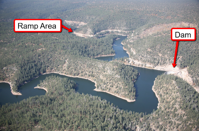
This aerial photo shows the location of the boat ramp in general proximity to the dam.
Aerial view of the dam and spillway on viewer's right hand side of dam.
Here's a view of the spillway looking from above and behind the dam.
This is a view of the dam looking up from downstream on "river right".
The spillway is out of view on the right side of this photo.
Here's a view of the spillway looking upstream from a point near the bottom of the spillway.
This is just about the most concise history of Blue Ridge Reservoir that you can get. SRP owns Blue Ridge now and here is a link to their story about the dam and reservoir:
Note that Blue Ridge Reservoir was renamed after it was acquired by SRP. No one we know will EVER call it by its so-called new name. It will ALWAYS be Blue Ridge Reservoir. Period.
Currently Blue Ridge Reservoir is closed to all public access while Arizona Game & Fish Dept. rebuilds the boat launch area. This and several photos below were taken February 13, 2017 by Coconino National Forest Public Affairs Officer Brady Smith. They were posted on and copied from the Coconino's Twitter account.
Above is a better view of the new boat ramp.
It's going to be a huge improvement over the old ramp. (See photo below.)
A new looped access route has been engineered and is being installed.
The right photo shows what it looks like when Blue Ridge is full. Coconino NF PAO Brady Smith went to Blue Ridge on February 13 to photograph the amount of water spilling out of the full reservoir. The low water photo was taken in October 2015 by Deborah Soltesz. Many Thanks to the Coconino National Forest for use of these fine photos.
Above is what the old boat ramp looked like. We've been there many, many a time under similar conditions. We have quite a few stories to tell about those "Good Old Days".
And when the water dropped really, really, REALLY low, this is what you would encounter at the Blue Ridge boat ramp. Hopefully, AZGFD was able to get the lower portion of the new ramp complete before the water rose and filled the reservoir.
Subscribe to:
Posts (Atom)


