Lots to write about Blue Ridge Reservoir. For now, we will simply try to explain where it is and what's going on with it. Captions are below each graphic or photo.
This is a "vicinity map" of Blue Ridge with respect to its location relative to Winslow & Grand Falls. The topic of Blue Ridge Reservoir came up on our Facebook page with respect to Grand Falls. We told our Facebook Friends that Blue Ridge Reservoir is full and spilling water as of February 13. The spillage will certainly help supplement potential "photo op flows" at Grand Falls for at least a few days. This post was put together to help our Facebook Friends understand a little bit about Blue Ridge Reservoir.
Blue Ridge Reservoir is located almost due East of Clint's Well but you have to drive
north of Clint's Well to get to the turn to go to Blue Ridge.
Here's a topo map of the reservoir showing the location of the dam and spillway.
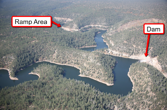
This aerial photo shows the location of the boat ramp in general proximity to the dam.
Aerial view of the dam and spillway on viewer's right hand side of dam.
Here's a view of the spillway looking from above and behind the dam.
This is a view of the dam looking up from downstream on "river right".
The spillway is out of view on the right side of this photo.
Here's a view of the spillway looking upstream from a point near the bottom of the spillway.
This is just about the most concise history of Blue Ridge Reservoir that you can get. SRP owns Blue Ridge now and here is a link to their story about the dam and reservoir:
Note that Blue Ridge Reservoir was renamed after it was acquired by SRP. No one we know will EVER call it by its so-called new name. It will ALWAYS be Blue Ridge Reservoir. Period.
Currently Blue Ridge Reservoir is closed to all public access while Arizona Game & Fish Dept. rebuilds the boat launch area. This and several photos below were taken February 13, 2017 by Coconino National Forest Public Affairs Officer Brady Smith. They were posted on and copied from the Coconino's Twitter account.
Above is a better view of the new boat ramp.
It's going to be a huge improvement over the old ramp. (See photo below.)
A new looped access route has been engineered and is being installed.
The right photo shows what it looks like when Blue Ridge is full. Coconino NF PAO Brady Smith went to Blue Ridge on February 13 to photograph the amount of water spilling out of the full reservoir. The low water photo was taken in October 2015 by Deborah Soltesz. Many Thanks to the Coconino National Forest for use of these fine photos.
Above is what the old boat ramp looked like. We've been there many, many a time under similar conditions. We have quite a few stories to tell about those "Good Old Days".
And when the water dropped really, really, REALLY low, this is what you would encounter at the Blue Ridge boat ramp. Hopefully, AZGFD was able to get the lower portion of the new ramp complete before the water rose and filled the reservoir.


